
False Pass, Alaska
Name: False Pass is a city in Aleutians East Borough, Alaska, United States. False Pass is an early English name for Isanotski Strait on which the City of False Pass is located. The strait was called “False Pass” by early American sailing ship captains because it was thought to be impassable for their deep draft vessels at the northern end. Isanostski Strait is called "The Pass" by fishermen in the area.
Historical Name: Before the arrival of the English-speaking sailors, the pass was called Isanax (variously spelled Issannakh, Isanak etc.) which is the Aleut name for present day Isanotski Strait. Isanax means gap, hole, rent, or tear <strait, pass> in the Aleut language which was rendered as Isanotski (or Issanakskie, Isanotskoi, Isanakh etc) in transliterated Russian. The strait appears as Исанакъ in 1802 and Исаноцкый in 1844 on Russian maps.
Isanotski Strait lies between the tip of the Alaska Peninsula and Unimak Island, the first of the Aleutian Islands and it connects the northern Gulf of Alaska with the Bering Sea. This strait was used for safe passage for millennia by Aleuts and later by the Russians during their occupation of the area. The strait is used today by most vessels less than 200 feet in length traveling to and from northern Alaska and points in southwest and southeast Alaska and the “lower 48” states. The common nickname for Isanotski Strait throughout southwest Alaska is "The Pass".
Official Status: A salmon cannery was built on the Unimak Island side of Isanotski Strait in 1919 which provided the nucleus for the modern community. A U.S. post office with the name of "False Pass" was established in 1921 at the salmon cannery which gave official status to the village. It was incorporated as a second class city in 1990. 1
The Geographic coordinates for False Pass, Alaska are:
54°49′40″N 163°23′57″W (54.827886, -163.399090)
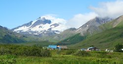
The central residential area of False Pass is located in a broad valley with Roundtop Volcano at its western end. This picture was taken from the beach, looking west. The brown house is built on the location of the original settlers. The school and residential subdivision are located just beyond these houses. Click on picture to see a larger version.
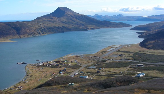
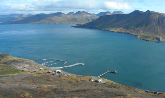
False Pass from above: This is a view of part of the City of False Pass, looking towards the southeast. Isanotski Strait separates Unimak Island, on which False Pass is located, from the tip of the Alaska Peninsula which is on the left. In the distance is Ikatan Bay and the mountains on Ikatan Peninsula. In the far distance on the left is the Gulf of Alaska. The old salmon cannery and docks are visible in the left middle. The City office, post office, clinic, public safety building and school are in the foreground. Click on picture to see larger version.
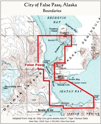
City Boundaries: When the City of False Pass became a legal "second class" city according to Alaska law in 1990, it did so primarily to secure the right to charge sales and use tax to support the school and new city government. The city's boundaries were extended to include the area shown above, part of the city being on Unimak Island and part on the end of the Alaska Peninsula. These boundaries include the abandoned villages of Morzhovoi, Sourdough Flats and Ikatan. It also includes the waters of Isanotski Strait and Ikatan Bay up to Ikatan Point (Cape Horn) where a raw fish tax can be levied by the city on commercial fish deliveries. 2
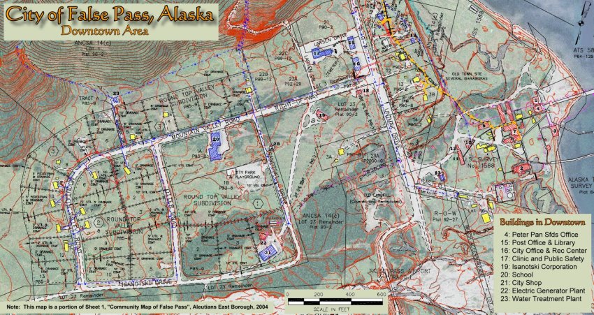
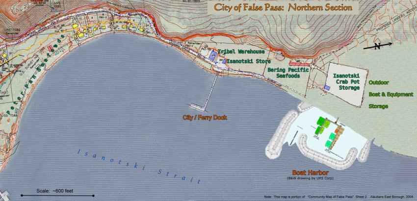
The Northern Section of False Pass:The photo to the right shows the northern section of False Pass. The houses seen in the lower right are part of the old original residential section of the village. Then, there is the City Dock which accomodates the Alaska State Ferry and is also used for general cargo. At the base of the dock is the Isanotski Grocery Store and Tribal Warehouse. Farther north is the new Boat Harbor. Next to the boat harbor is the Bering Pacific Seafoods plant. Just north of that is the Isanotski Crab Pot Storage area.
Isanotski Strait is the waterway seen here and on the opposite shore is the Alaska Peninsula. A small sliver of Trader's Cove is visible in the upper left on which the old village of Morzhovoi is located. Click on picture for a larger version.
Map of the Northern Section of False Pass: Click on map for a larger version.
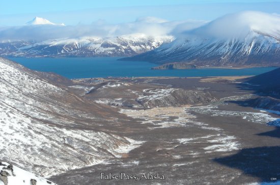
False Pass is located on Isanotski Strait at the mouth of a large valley. In the photo to the right, one can see the village located on The Pass with the Alaska Peninsula in the background. The high snow-capped mountain on the horizon is Mt. Frosty near Cold Bay. Frosty is a stratovolcano with an elevation of 6,299 ft (1920 m).
The hill in the middle of the valley is locally called the "island". There is a trail that leads to the meadow on top of the island from where there is a great view of Roundtop Volcano to the west. The valley's main stream is fed by glaciers and melting snow and is dry at the surface during the coldest winter months. During warm and wet periods, snowmelt causes the stream to increase in volume rapidly and bring down a lot of gravel and debris into The Pass. Click on picture for a larger version.
References:
1) Data modified from Wikipedia entry for False Pass, Alaska; http://en.wikipedia.org/wiki/False_Pass,_Alaska
2) City of False Pass Ordinances, found at: http://home.gci.net/~cityoffalsepass/city_ordinances.htm