
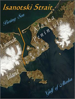
Isanotski Strait was called Isanax̂ by the Unangan (Aleut) people. Isanax means gap, hole, rent, or tear (pass, strait) in the Aleut language and is variously spelled Issannakh, Isanak etc. in English. The name was rendered as Isanotski (or Issanakskie, Isanotskoi, etc) in transliterated Russian. 2The name of Isanotski Strait evolved over time, from Aleut to Russian to English. The original Aleut name essentially meant "the Pass", but the meaning of the Aleut word was lost on the Russian speakers. The Russians always used some version of the original word, Isanax, usually choosing the Russianized version, Isanotski. When the English speakers entered the scene, they introduced a name that meant the opposite of the original, namely, "False Pass" because they could not easily sail through the narrow northern channel with their deep draft sailing vessels. The name, "False Pass", was reinforced when a post office was created at the cannery, using that name. One author suggests that Captain James Cook first introduced the name "False Pass" for Isanotski Strait when he visited the area on his third voyage in 1778.1
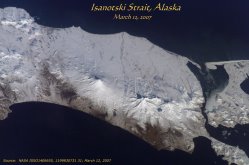
The space shuttle photo of Isanotski Strait above shows the gap between the tip of the Alaska Peninsula and Unimak Island, the first of the Aleutian Islands. This gap, The Pass, has been the best way for small and medium sized vessels to travel between the Gulf of Alaska and the Bering Sea for thousands of years. Isanotski Strait is called "The Pass" by fishermen throughout southwestern Alaska.
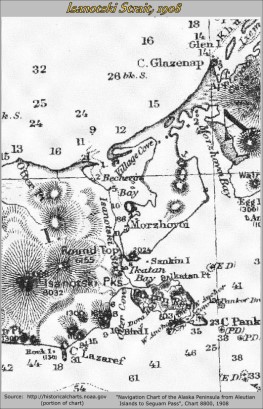
The chart above shows that by 1908, the modern names in the area had been well established. Ikatan Peninsula had also become firmly attached to Unimak Island by that time. Click on chart for larger version.
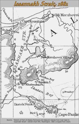
Isanotski Strait in American times is shown on the 1882 chart to the right where it is spelled Issannakh, following the original Aleut word. This shows that the early Americans tried to use the original name but later map makers chose Isanotski.
This chart also shows "Isanotski Point" which was the southeastern corner of Unimak Island, near the southern entrance to Isanotski Strait. Ikatok was clearly an island until then, even though it was already called a peninsula by the Americans. Ikatok was separated from Unimak Island by a stretch of shoal water. The Aleut villages of Old Morzhovoi and New Morzhovoi are also shown. Village Cove is now called Hook Bay.
Click on chart to see a larger version.
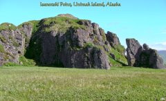
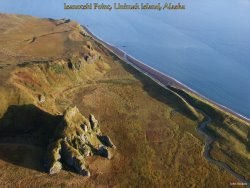
This is Isanotski Point in the year 2008. These bluffs were the southeast extremity of Unimak Island until around 1895 when the shoal waters separating it from Ikatok Island silted in and the area became dry land. The bluffs are the tip of a lava flow and sea waves created several small caves at sea level. Zakhar Dushkin from Morzhovoi Village said that he paddled a kayak past this point into what is now Otter Cove, when he was a boy in the 1890's. 3 Click on picture for larger version.
Isanotski Point is seen from the air to the right, looking northward. The highly dissected point at the lower left, is shown in detail in the photo at the upper right.
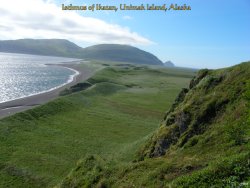
After the shoal waters off the Isanotski Point area became dry land in the 1890's, a long and broad isthmus was created that now connects Unimak Island with Ikatan Peninsula. The isthmus photo to far right was taken from above point, looking southeast. Click on photos for larger versions.
The Isanotski Strait name during the Russian period changed over time. On the maps on the right, in 1802 the original Aleut name was retained---Isanak, but with the Russian word "proliv" for strait added. By 1826, Sarychev called it Isanotskoi Strait, a modification of the Aleut name to sound more like Russian (pronounced Isanotski). In this way, the original Aleut name of Isanax, meaning gap, hole or tear (pass, strait), was mostly lost. But its original meaning is still embedded and hidden in the name Isanotski.
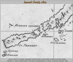
The Ikatan Peninsula was clearly an island in Russian times. Ostrov means island in Russian. It was called Os. Ikatanak in 1802 and Os. Ikatuk in 1826. Click on maps to see larger versions.
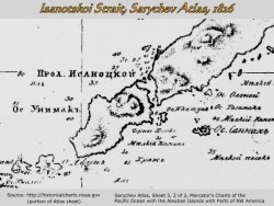
Sanak Island was called Sanakhak in 1802 and Sannak in 1826. The charts improve in accuracy over time, but even so, Morzhovoi Bay is not shown in 1826.
Isanotski Strait in modern times is the primary pass for vessels traveling to and from Northern Alaska, Bristol Bay and southwestern Alaska and the lower '48.
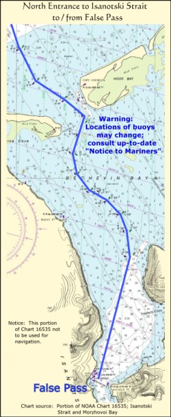
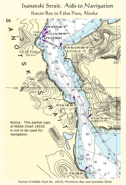
The Pass is shown on the two partial charts to the right. Click on the small charts to see larger versions.
The southern section of The Pass is deep and will accomodate large ships. Mariners unfamiliar with The Pass and its powerful currents should consult the most recent tide and current tables, charts and Coast Pilot for accurate information on Isanotski Strait.
The northern section of The Pass goes through shallow Bechevin Bay before entering the Bering Sea. Before the installation of modern buoys and navigation aids, the northern section of Isanotski Strait required local knowledge for safe navigation. Today, the entire channel is fully buoyed and maintained by the U.S. Coast Guard so that safe navigation is possible for most vessels less than 200 ft long. More local information on The Pass can be obtained by calling the False Pass City Office on VHF channel 6.
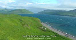
The southern entrance to Isanotski Strait can be seen in the distance in this photo. The navigation aid that guides vessels into the strait can be seen atop the bluff in the foreground. This same aid is the also shown on the chart below. Click on picture to see a large version.
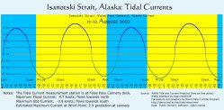
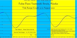
Isanotski Strait/False Pass Currents & Tides are shown in the graphs on the right. Click on graphs for larger versions.
The reference station for tidal currents in Isanotski Strait is at False Pass on the old cannery dock. The reference station for tidal range is Unalaska.
Isanotski Strait is usually free of winter ice. However, in particularly cold winters, ice chunks from the edge of the Bering Sea ice pack break off and make their way into The Pass with the ebbing tide. Also, with perisistent cold weather, fresh water ice is created at the heads of bays where streams enter. The tides and wind then move the ice into and through The Pass. The wooden piling dock at the False Pass cannery has been heavily damaged several times by drifting ice in The Pass.
The space shuttle photo from March 12, 2007 above shows ice moving into Isanotski Strait from the Bering Sea with help from the tide and wind. Click on photo for larger version.
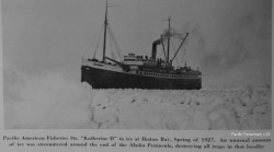
Ice in Ikatan Bay and Isanotski Strait was heavy in the spring of 1927. Above is a Pacific American Fisheries (PAF) steamship in the ice in Ikatan Bay. PAF owned the salmon cannery in Ikatan and also several salmon traps nearby. Click on picture for larger version.
References:
1) Lassegard, Harlan J. "Isle of Discovery", Trafford Publishing, 2006, pg 173.
2) Father Paul Merculieff, personal communication.
3) Zakhar Dushkin, personal communication.