
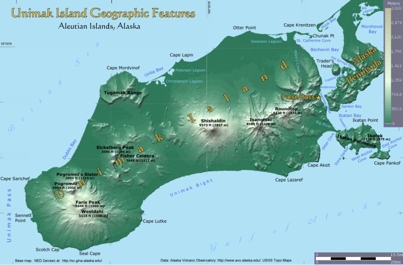
Most of the volcanoes on Unimak Island are called "stratovolcanoes", seen in graphic form on the right. Stratovolcanoes are sometimes called "composite volcanoes" because of their composite layered structure built up from sequential outpourings of eruptive materials such as ash, lava, pumice and tephra. They are among the most common types of volcanoes.
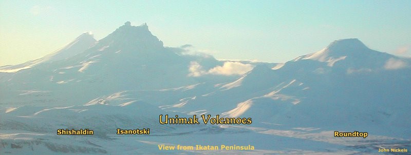
On Unimak Island, Shishaldin is a stratovolcano that is still active and because it is frequently putting down fresh material, stands out as a symmetrical cone. Isanotski and Roundtop are dormant stratovolcanoes that have undergone significant erosion producing their unique forms.
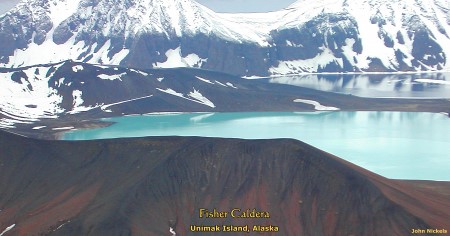
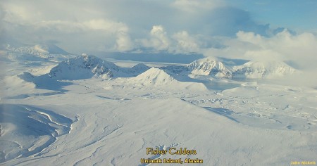
Fisher caldera was the location of a large andesitic stratovolcano that was largely destroyed during caldera formation.1
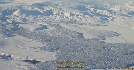
Westdahl Peak, including nearby Faris Peak and Pogromni volcano, is defined as a "shield volcano" by AVO and is located on a gently sloping plateau that may represent the surface of a truncated ancestral cone.1
Unimak Volcanoes: Eastern Section
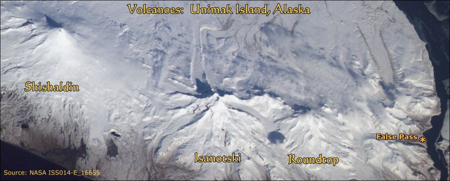
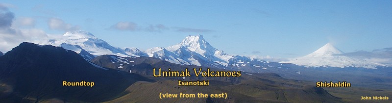
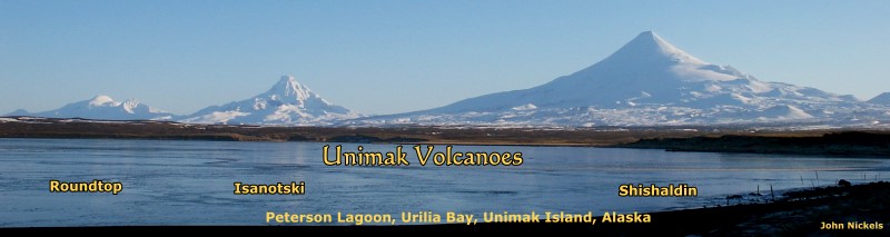
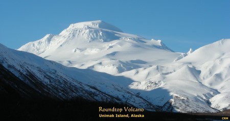
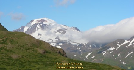
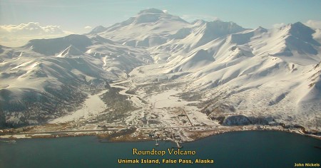
Roundtop Volcano is located near the eastern end of Unimak Island. This inactive volcano dominates the western end of a broad valley west of the village of False Pass.
Type: Stratovolcano
Seismically Monitored: No
Distance: 661 mi (1064 km) from Anchorage
Elevation: 6138 ft (1871 m)
Latitude: 54.7992° N Longitude: 163.5914° W
Quadrangle: False Pass
CAVW Number: 1101-38- 1"Roundtop is an eroded and glaciated stratovolcano, located ~13 km southwest of the village of False Pass. In the 1930's warm springs were found on its slopes. Recent field study indicates the presence of Holocene pyroclastic flows and a group of domes south of Roundtop, as well as a thick silicic pre-Holocene flow."1
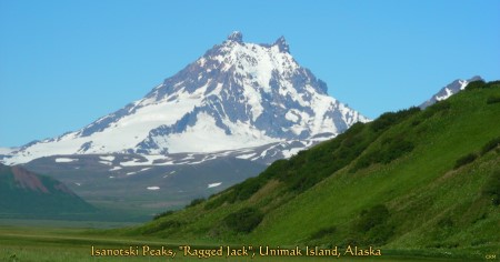
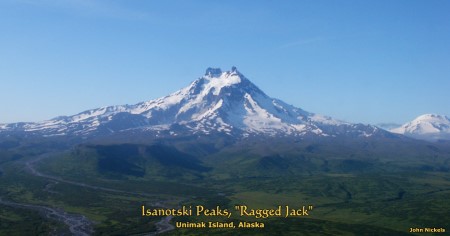
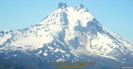
Isanotski Volcano is located towards the eastern end of Unimak Island. There is no verified historical eruption of Isanotski.1
Type: Stratovolcano
Seismically Monitored: Yes
Current Color Code: GREEN
Distance: 667 mi (1073 km) from Anchorage
Elevation: 8104 ft (2470 m)
Latitude: 54.76799° N Longitude: 163.72904° W
Quadrangle: False Pass
CAVW Number: 1101-37-1"Isanotski volcano, located near the eastern end of Unimak Island, is a dissected, snow- and ice-covered stratovolcano with a basal diameter of about 10 km. It is much more deeply eroded than neighboring Shishaldin volcano and lies between Shishaldin and Roundtop along a roughly east-west alignment."1
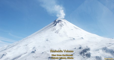
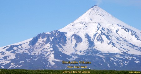
Shishaldin Volcano is located near the center of Unimak Island.
Type: Stratovolcano
Most Recent Activity: February 17, 2004
Seismically Monitored: Yes
Current Color Code: GREEN
Distance: 674 mi (1084 km) from Anchorage
Elevation: 9373 ft (2857 m)
Latitude: 54.7554° N Longitude: 163.9711° W
Quadrangle: False Pass
Unimak CAVW Number: 1101-36-1"Shishaldin Volcano ... is the highest peak in the Aleutian Islands and has a small summit crater from which a steady cloud of steam is emitted. The upper 2000 m is almost entirely covered by perennial snow and ice. It is flanked to the northwest by 24 monogenetic parasitic cones (Fournelle, 1988). The Shishaldin cone is less than 10,000 year old and is constructed on a glacially eroded remnant of an ancestral soma and shield (Fournelle, 1988), which in turn are underlain by volcaniclastic rocks of probable late Tertiary age (McLean and others, 1978). Fournelle (1988) suggests that the basement may consist, at least in part, of plutonic rocks."1
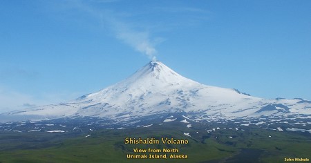
Shishaldin has been very active during modern history with the last eruption in 2004. There are 56 events listed for Shishaldin since the earliest reports by the Russians in 1775 although some of these were non-eruptive events and others are questioned.1
AVO maintains a webcam on Shishaldin which can be seen here.
Unimak Volcanoes: Western Section
"Fisher caldera is 11 km wide by 18 km long, and has a maximum internal relief of 929 m. It is one of at least three volcanoes on Unimak Island that have been active in historical time."1
Type: Caldera with post-caldera domes,
lava and pyroclastic flows
Most Recent Activity: August 1830
Seismically Monitored: Yes
Current Color Code: GREEN
Distance: 688 mi (1108 km) from Anchorage
Elevation: 3648 ft (1112 m)
Latitude: 54.6692° N Longitude: 164.3524° W
Quadrangle: Unimak
CAVW Number: 1101-35-"The caldera is remarkable in size - one of the largest calderas in the Aleutian arc - and for the mobility of the ash flows that resulted from the caldera-forming eruption about 9100 years ago (Miller and Smith, 1977; 1987). The ash flows reached the Pacific Ocean 8 km to the southeast, and swept part way up the slopes of stratovolcanoes to the east and southwest. To the north, ash flows crossed 15 km of lowland to reach the Tugamak Range, surmounted drainage divides as much as 400 m above the lowland surface in the range, and continued northward an additional 8 km to the Bering Sea coastline. Miller and Smith (1977) inferred that the ash flows had unusually high velocities to cross such topographic barriers and suggested that the high velocities resulted by ash fall-back from a high eruption column."1
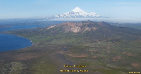
Fisher Caldera with Shishaldin and Isanotski in background.
"Fisher caldera was the location of a large andesitic stratovolcano that was largely destroyed during caldera formation. Very little study has been done on the caldera itself. Post-caldera activity of Fisher caldera appears to consist of dome emplacement and eruption of lava flows and associated pyroclastic material, some of which may be historical in age (Miller and Smith, 1977)."1
There are three reported events at Fisher, but they may have not been eruptions.1
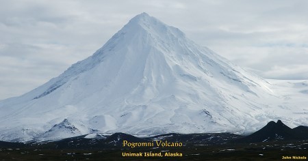
"Westdahl Peak, including nearby Faris Peak and Pogromni volcano, is located on a gently sloping plateau (mean elevation 1220 m) that may represent the surface of a truncated ancestral cone. Westdahl Peak is about 18 km in diameter at the base.1
Type: Shield volcano
Most Recent Activity: November 29, 1991
Seismically Monitored: Yes
Current Color Code: GREEN
Distance: 705 mi (1134 km) from Anchorage
Elevation: 5118 ft (1560 m)
Latitude: 54.5171° N Longitude: 164.6476° W
Quadrangle: Unimak
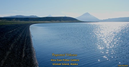
CAVW Number: 1101-34-1"Based on the degree of erosional dissection, most of the postulated stratovolcano must have formed before early post-glacial time. Pogromni Volcano is moderately dissected and has broad valleys that have probably been glacially eroded. Such glacial erosion could have occurred during neoglaciation beginning about 3000 years ago (Black, 1974, table 1), although one or two thousand years seem inadequate to account for the degree of dissection. Pogromni volcano was probably active by latest Pleistocene time, which implies that truncation of the ancestral stratovolcano must have occurred earlier."1
"The size of the postulated ancestral cone is about 19 x 30 km at sea level, making it one of the largest volcanoes in the Aleutian Islands be it a stratovolcano or a shield. The entire ancestral cone has been extensively dissected by erosion, with the northeast-facing slopes steeper and of greater relief than the other slopes."1
References:
1) Alaska Volcano Observatory: http://avo.alaska.edu/volcanoes/ (see appropriate volcano entry) N.B.: Website data retrieved 1 Feb 2011