
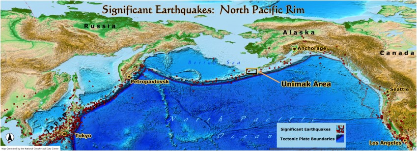
The Unimak Area is located in one of the world's most active tectonic plate boundary zones. The Rim of the North Pacific experiences many significant earthquakes as shown in the map above.8 The frequent earthquakes and active volcanism that occur in the entire Alaska Peninsula and Aleutian Island chain are the direct consequence of the Pacific oceanic plate colliding with the North American continental plate. Since the oceanic plate is heavier than the light continental crust plate, it subducts under the North American plate. As a result of this continuous subduction process, great stresses and heat are created in the subduction area and frequent earthquakes are produced as well as strong volcanic activity. When strong earthquakes occur under the ocean in this area, tsunamis are sometimes created.
The Aleutian Trench, that runs all along the Alaska Peninsula and the Aleutian Islands, marks the location of the subducting Pacific plate. The Aleutian Trench just south of Unimak Island is 22,638 feet deep.

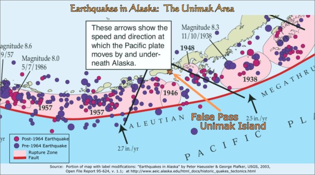
Earthquakes in the Unimak Area occur in the tectonic plate subduction zone as shown in the map below. The map groups the earthquakes before and after the "Great Alaska Earthquake of 1964". The major Aleutian Fault is shown in red.
The Shumagin Gap is an area between Unimak Island and the Shumagin Islands that does not seem to have experienced a rupture to release accumulated stress since about 1903 (see map below). The documented rupture zones are shown in the pink areas on the map with the dates of the earthquake that released the stress energy. Some geophysicists predict that the Shumagin Gap could be the source of a major devasting earthquake. Others think that the stress could be released through the subducting plate freely slipping.2,3
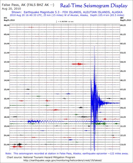
Seismicity in the Unimak Area is now monitored locally through a real-time seismograph station installed on Unimak Island at False Pass. The seismogram from the station on the lower right shows a 5.3 magnitude earthquake that occured approximately 122 miles away near Akutan to the west. This earthquake did not cause damage locally. This seismograph is part of a USGS monitoring system for the Aleutian area.
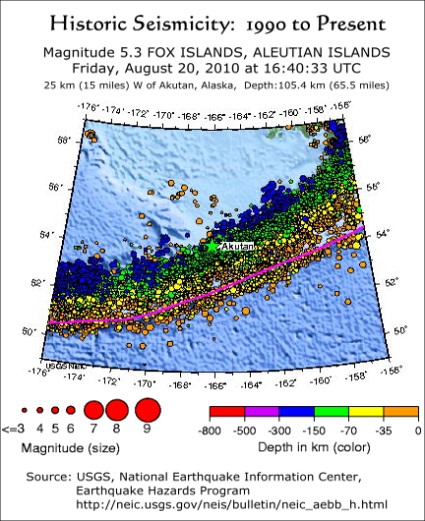
Historic seismicity of the area is shown on the map to the lower left where all the earthquakes since 1990 have been plotted. There were hundreds of small earthquakes during the period and this is typical for the entire East Aleutian Volcanic Arc where the subduction process is like a continuous conveyor belt. Although earthquakes are very frequent they are usually less than 5.0 magnitude, but an occasional powerful destructive quake does happen, sometimes causing massive tsunamis and damage to property on land. On the map, the topography is obscured by the data circles, but False Pass is located east of Akutan at approximately 55° N, 163° W. Each earthquake is coded as to magnitude by circle size and to depth by color. When this map is compared to the schematic diagram of the subduction zone above, it can be seen very clearly that the density and depth of the earthquakes is entirely related to the form and movement of the subducting plate. As you move away from the subducting oceanic plate, earthquakes frequency diminishes very rapidly. Clearly, the Unimak Area is one of the earth's most active seismic areas and community planning should take this fact very seriously.
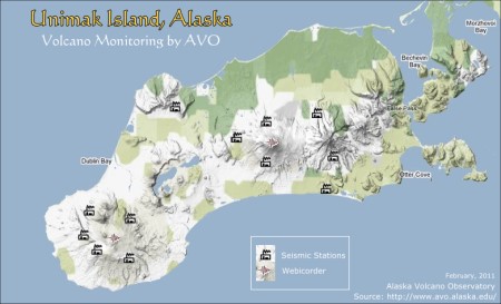
The volcanos on Unimak Island are currently being monitored by an array of seismic sensors operated by the Alaska Volcano Observatory.6 The most active volcano being monitored is Shishaldin. A preliminary hazard assessment found:
"Future eruptions are likely to be similar in size to those of the last few hundred to few thousand years, and the most likely volcanic hazard is the eruption of plumes of volcanic ash that could rise ten kilometers or more into the atmosphere. Such ash plumes would constitute a hazard to aircraft flying long-distance routes over the North Pacific Ocean, as well as those flying more local routes over Unimak Island and the eastern Aleutian Islands. More than 200 flights travel over the region each day (Miller and Casadevall, 2000). Ashfall from eruptions might also affect shipping and fishing activities around Unimak Island. Lava flows, floods, lahars, and small pyroclastic flows and surges may also accompany future eruptions, and would preferentially affect low-lying areas within 10 kilometers of the volcano."5
A tsunami over 100 ft high, triggered by an earthquake south of Unimak Island, struck the Scotch Cap Lighthouse at 2:18 a.m on April 1, 1946. The lighthouse was completely destroyed and the entire five-man crew was killed.1 The earthquake was ~7.3 magnitude. A good account of the disaster can be read here. Scotch Cap is located on the southwest end of Unimak Island and it overlooks Unimak Pass, separating Unimak Island from the Krenitzen Islands to the west.
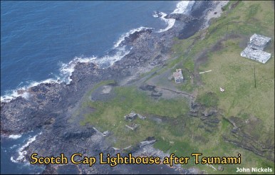
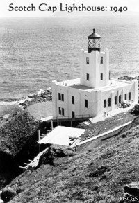
The Scotch Cap Lighthouse before the tsunami is seen above. It was 40 feet above the sea, 5 storeys high and made of concrete and steel. An un-manned light house was built in 1950, then a skeletal tower replaced the 1950s structure and the light was automated in 1971.1
The Scotch Cap Light serves Unimak Pass, an important shipping lane for sea freight between the west coast of the U.S. and Asia.
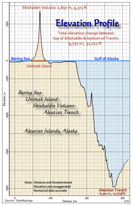
The graph above shows the Aleutian Trench that lies just off shore on the south side of the Alaska Peninsula and Aleutian Islands. The trench marks the area where the Pacific plate is subducting under the North American Plate.
The above profile starts on the Bering Sea coast of Unimak Island and then goes over the highest point on Unimak Island, Mt. Shishaldin, and then south across the Aleutian Trench, revealing a total elevational change of 32,011 feet. The area to the right of the trench is part of the subducting Pacific plate.
Geology of the Unimak Area
The geology of the Unimak Area has been created by the forces arising in the tectonic plate boundary and subduction zone along the East Aleutian Volcanic Arc.
The most recent rocks are relative young, originating from volcanic activity that is on-going. These areas are shown in yellow. The grey areas show a mixture of rocks of different ages, many unconsolidated. Some of the islands south of the Alaska Peninsula could be "terranes" * that have been rafted to this location on the moving tectonic plates.
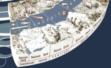
Click on graphic below for a perspective geologic time scale to facilitate understanding the geologic maps.7
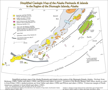
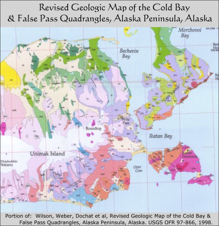
The Geology of most of the Unimak area is presented in detail on the map to the right.
Click on map to see a large half-sized version (2491 x 1821 px). For the full sized version of the map, a 12 MB pdf file, click here.This geologic map covers the Cold Bay and False Pass quadrangles and so excludes about one half of Unimak Island. Nevertheless, it provides an excellent reference for the geology of the Unimak Area and the lower Alaska Peninsula.
One of the authors of the geologic map, Wilson, added some interesting comments about this area:
"Conceptually, the Aleutian Islands begin at Pavlof Bay; if not for the glacial deposits linking things together at Pavlof, Cold, and Morzhovoi Bays, the islands would start with Pavlof Volcano. Bechevin Bay deposits almost linked Unimak Island too. The rocks immediately around False Pass are geologically young, possibly no more than 5-10 million years old and hence postdate the bulk of this moving around.""The glacial deposits are an interesting story in themselves. They clearly indicate that the main glacier mass was offshore to the south of the Alaska Peninsula; this causes a certain amount of heartache for the traditionalists because it turns the flowing from the mountains to the sea idea on its head. People are beginning to come around to this though because the deposits are pretty unequivocal."4
References:
1) http://www.uscg.mil/history/weblighthouses/LHAK.asp
2) Fournier, T. J., and J. T. Freymueller (2007), Transition from locked to creeping subduction in the Shumagin region, Alaska, Geophys. Res. Lett., 34, L06303, doi:10.1029/2006GL029073.
3) Davies, J., L. Sykes, L. House, and K. Jacob (1981), Shumagin Seismic Gap, Alaska Peninsula: History of Great Earthquakes, Tectonic Setting, and Evidence for High Seismic Potential, J. Geophys. Res., 86(B5), 3821–3855, doi:10.1029/JB086iB05p03821.
*) Terrane = "It is a piece of crust which has been transported laterally, usually as part of a larger plate, and is relatively buoyant due to thickness or low density. When the plate of which it was a part subducted under another plate, the terrane failed to subduct, detached from its transporting plate, and accreted onto the overriding plate. Therefore, the terrane transferred from one plate to the other. Typically, accreting terranes are portions of continental crust which have rifted off another continental mass and been transported surrounded by oceanic crust, or old island arcs formed at some distant subduction zone." (Wikipedia: Terrane)
4) Frederick (Ric) Wilson, personal communication
5) Begét, J.E., Nye, C.J., Schaefer, Janet R., and Stelling, Peter L. "Preliminary Volcano-Hazard Assessment for Shishaldin Volcano, Alaska", Alaska DNR, Div. Geological & Geophysical Surveys, Report of Investigations 2002-4, 2003
6) The Alaska Volcano Observatory (AVO) is a multi-agency organization composed of the US Geological Survey (USGS), University of Alaska Fairbanks Geophysical Institute (UAFGI), and the Alaska Division of Geological and Geophysical Surveys (ADGGS) Website at: http://avo.alaska.edu/
7) Graham, Joseph, Newman, William, and Stacy, John, 2008, The geologic time spiral—A path to the past (ver. 1.1): U.S. Geological Survey General Information Product 58, poster, 1 sheet. Available online at http://pubs.usgs.gov/gip/2008/58/
8) National Geophysical Data Center (NOAA): http://map.ngdc.noaa.gov/website/seg/hazards_pacific/viewer.htm